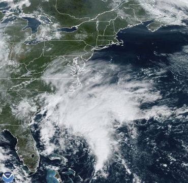
A tropical storm warning covering a stretch from coastal North Carolina to Delaware has been issued ahead of a potential tropical cyclone approaching the densely populated East Coast of the US.
The National Hurricane Centre announced the formation of “Potential Tropical Cyclone Sixteen” on Thursday. The storm was located about 340 miles southeast of Charleston, South Carolina, and moving north, according to an 8pm advisory from the centre. The storm had top sustained winds of 35mph.
The hurricane centre defines a potential tropical cyclone as a disturbance which poses a threat of tropical storm or hurricane conditions to land within 48 hours. The current system could reach the North Carolina coast on Friday night or early on Saturday.
Meteorologist Maria Torres, a public affairs officer with the Miami-based centre, said people along the Atlantic coast need to watch the storm’s progress, gather supplies and make preparations over the next 24 to 48 hours.
What is a "Potential Tropical Cyclone?"
It's a system that could become a tropical depression or tropical storm and brings hazardous conditions to land within the next 48 hours. NHC can issue its standard forecast products for these systems, including watches and warnings. pic.twitter.com/Nt1kgVCxceAdvertisement— National Hurricane Center (@NHC_Atlantic) September 21, 2023
“This will bring some tropical storm force winds and storm surge along with the high winds to the East Coast through the weekend, mainly from the Southeast to the Mid-Atlantic states,” she said.
The tropical storm warning runs from Cape Fear, North Carolina, to Fenwick Island, Delaware. It includes the Chesapeake Bay south of North Beach, Tidal Potomac south of Cobb Island and Albemarle and Pamlico Sounds.
Virginia emergency management officials warned of heavy rain, high winds and flooding in the next few days.
The Virginia Department of Emergency Management said on social media that officials are co-ordinating with local weather service offices to watch the system developing off the coast. Officials called on residents to prepare for the storm and impacts on the region throughout the weekend.
A storm arriving late Friday will bring nearly statewide impacts to Virginia through Sunday morning. Start preparing!
We have a potential for:
🌧️1-4" of rain, some higher amounts
🌬️sustained winds of 35mph, gusts to 45-55mph near the coast
🌪️isolated tornadoes
🌊tidal flooding pic.twitter.com/PByCfGZS3G— Virginia Department of Emergency Management (@VDEM) September 21, 2023
North Carolina Emergency Management warned that large swells from distant Hurricane Nigel would also reach the state’s coast on Thursday, boosting the rip current risk. The combination of those swells and the low-pressure system could mean additional ocean overwash, beach erosion and coastal flooding.
The hurricane centre said a storm surge between two and four feet was expected.
A storm surge warning is in effect from Duck, North Carolina, to Chincoteague Virginia, including Chesapeake Bay south of Windmill Point, and for the Neuse River, the Pamlico River, and portions of Pamlico Sound.
A storm surge watch also was issued from Surf City in North Carolina to Duck, North Carolina, along with Chesapeake Bay north of Windmill Point to Smith Point, the Tidal Potomac south of Colonial Beach and Albemarle and the remainder of Pamlico Sound.


